Deimos-1, orbiting at an altitude of 670 kilometers, captured photographs between three and four hours after the catastrophe.
The first photographs of Japan taken from space after the tsunami were captured by Deimos-1, a satellite that is 100% Spanish, according to the webpage of the UN.
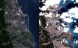
Specifically, the satellite developed by the company Deimos Imaging captured two large-sized images, which have provided a rapid understanding of conditions in the area affected by the tsunami.
The resolution of the photographs is 20 meters, less than that provided by other foreign satellites; however, in spite of this difference, the advantage to be found is the speed with which the images were taken and the wide sweep of the satellite. These characteristics have enabled visualizing practically all of Japan, including the Fukushima nuclear plant, which appears pixelated.
Deimos-1, located at an altitude of 670 kilometers, captured the photographs of the catastrophe between three and four hours after it happened. In total, only about twelve hours passed before the UN could see them.
During this time, the photographs were downloaded to a company base located on the Norwegian island of Svalbard, close to the North Pole. There they were processed and delivered to the UN, which is now using them to coordinate rescue and aid efforts.
Deimos-1 is the only Spanish Earth-observation satellite. Currently a second model is being developed, with a budget of €50 million, that will improve image clarity. The Spanish company expects that Deimos-2 can be functioning in 2013.