The radiometer for the SMOS satellite was built by EADS CASA Espacio in Spain. It collects data about soil moisture and ocean salinity on Earth, two decisive variables in tracking the evolution of climate change.
At the end of 2009, the ESA (European Space Agency) launched the SMOS satellite in order to analyze the Earth’s water cycle. The satellite’s useful life was expected to be five years, but the mission’s success has led this to be extended for an additional three years.
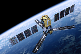
The key to this success is the excellent performance of MIRAS (Microwave Imaging Radiometer with Aperture Synthesis), an innovative aperture synthesis microwave radiometer which supplies data about soil humidity and oceanic salinity. These two variables are decisive in determining the fate of the Earth’s climate and in tracking the evolution of climate change.
The technology that enables acquiring this information was developed by Airbus DS España, and it’s 100% Spanish. MIRAS is a small, aperture synthesis antenna. Once its three arms are deployed in orbit the antenna’s performance is similar to that of a much larger one, which would be difficult to launch into space using conventional methods.
Salinity is a variable that, together with humidity, determines water density. Differences in density between bodies of water are what provoke marine currents, which in turn have a great degree of influence on climate variability and lead to innumerable droughts and floods.
SMOS sends this data back to ESAC on Earth, the ESA’s European Space Astronomy Center located in Villafranca del Castillo (Madrid). From there this information is distributed to scientists around the world, among them Spain’s ICM (Institute of Marine Sciences) which continues to improve its algorithms related to salinity.