FutureWater is creating an early detection and tracking system for drought that helps prevent crop damage. The company has already completed the first module of this system, which measures the verdure of vegetation using information gathered from NASA’s Modis satellite.
The operating system developed by FutureWater, a spinoff linked to the Technical University of Cartagena (Universidad Politécnica de Cartagena), consists of several modules that measure variables such as the verdure of vegetation, precipitation and the amount of water available in reservoirs, rivers and dams.
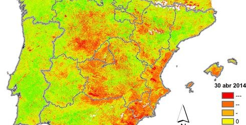
For now, FutureWater has completed the module measuring the Normalized Density Vegetation Index (NDVI), obtained from images provided by NASA’s Modis earth observation satellite. This Index calculates the amount of green biomass—active from the standpoint of photosynthesis—that exists in a given surface area. During periods of heavy rain higher levels of green biomass generation (verdure) can be expected. By calculating the deviation in verdure that exists in a specific surface area from the average rate observed over a given period, it’s possible to come up with an indirect measure of a drought’s severity and the impact it is having on crops.
After showing how well the verdure index works, researchers from FutureWater are now at work developing other modules based on indicators that are not obtained from satellite data, such as rainfall levels and kinetics (to measure the flow of water in rivers and streams).